Fuel management and wildfire mitigation proposal for the University of California property in Strawberry and Claremont canyons
Joe R. McBride
Professor Emeritus of Forestry, University of California, Berkeley, California Licensed Professional Forester #1306
September 15, 2019
Introduction
Portions of the residential areas of Berkeley and Oakland adjacent to the University of California campus and the Lawrence Berkeley National Laboratory are in a very high fire hazard zone. This situation is due to the vegetation, topography and climatic conditions occurring in the area. These conditions were responsible for the rapid spread of the 1991 Oakland Tunnel Fire that killed 25 people and consumed 3,276 homes and apartments. Little can be done about the topography and climatic conditions of the area, but residential hardening of homes with defensible space in combination with agency fuel management can reduce the heat released by a fire, the rate of fire spread, and the production of embers. Fuel management can also provide space for firefighters to assemble and undertake fire suppression activities.
The purpose of this report is to present a fuel management plan for University of California property located in Strawberry and Claremont canyons. The plan will identify site-specific fuel reduction treatments to reduce the fire hazard present in naturally occurring vegetation types and to convert highly hazardous plantations of eucalyptus and conifer species to less hazardous naturally occurring vegetation types. The plan also will address the question of the safety of evacuation routes in the area during future fires. The following report presents cost estimates for the proposed management activities and evaluates the impact of the plan on rare and endangered species.

Characteristics of the study area
Climate
The study area occurs within a broad Mediterranean climate characterized by dry summers and wet winters (Russell, 1926). Current summer temperatures typically reach maxima around 90oF (32oC), while winter lows average just above freezing. A recent study by the Union of Concerned Scientists (Dahl, 2019) projected how many days in different areas will reach temperatures of 90 degrees, 100, 105, and what they call “off-the-chart” hot. For example, Oakland, which historically does not have any days over 100 degrees, will average 16 days of century heat per year by the end of the century.
The local Mediterranean climate is characterized by coastal summer fog. Fog usually persists until mid-morning from May through July in the higher elevations of the canyons. This summer fog tends to effect a higher fuel moisture level than is the case for locations further inland. Winds throughout most of the year come from the west and southwest, but may blow from the east and northeast under atmospheric conditions that result in Diablo winds (SJSU, 2019). These winds can reach sustained velocities of 50 mph and are dry with relative humidity as low as 10%. Diablo winds, which blow down both Strawberry and Claremont canyons, can carry fire into the adjacent and downwind areas of Berkeley and Oakland.
The topography of the area results in a number of microclimates that can affect fuel moisture and fire behavior. South facing slopes are generally 5 to 10 degrees warmer than north facing slopes. Fuels dry out faster on these south facing slopes. Slope steepness influences flame length and the rate of fire movement during a fire, steeper slopes resulting in greater flame length and more rapid fire movement. The typical movements of winds are up slopes and up canyons during the afternoons, except in periods of Diablo winds. During Diablo winds the wind blows down slopes and down canyons.
Topography

Strawberry and Claremont canyons are situated in the Oakland-Berkeley Hills (Map 1). They parallel each other in their orientation and topography (Map 2). The canyons are oriented along northeast to southwest axes. They extend from a ridge along their northeastern boundary paralleling Grizzly Peak Boulevard to the piedmont at the base of the hills. The highest elevations along this ridgeline approach 1,800 feet (550 meters) at the site of the AT&T towers. Both canyons narrow in width as they reach the piedmont below the hills. Stream elevation at the outlet of Strawberry Canyon is around 400 feet (137 meters) near California Memorial Stadium. The corresponding lower elevation in Claremont Canyon is around 450 feet (137 meters) near the Claremont Hotel and Spa. The side slopes of the canyons are generally oriented to the north and to the south. Slope steepness exceeds 50% over much of the north and south facing slopes in both canyons. The steep slopes of the canyons constrain the use of fire engines except on paved streets and unpaved fire roads and along the ridges where roads and fire trails exist. Slope steepness also limits the use of tractors (bulldozers) in firefighting. Slopes steeper than 50% are considered too steep for the use of tractors (California Department of Forestry and Fire Protection, 2019).
Vegetation
The principal vegetation types occurring in Claremont and Strawberry canyons are (1) annual grassland, (2) baccharis brushland, (3) oak woodland, (4) eucalyptus plantations, and (4) conifer plantations. The first three of these types will be referred to as naturally occurring types because they were not the result of planting of given species, as is the case of the eucalyptus and conifer plantations. Two of the naturally occurring types (baccharis brushland and oak woodland) are native types in that they were present when people came into the Bay Area. The annual grassland developed during the Spanish and Mexican periods in California as a result of the introduction of livestock and the inadvertent introduction of European annual grass seeds (Burcham, 1957). The distribution of these types in the study area is shown in Map 3. The approximate acreage of each vegetation type is shown in Table 1.


The annual grasslands are characterized by European annual grasses that include wild oat (Avena fatua), soft chess (Bromus hordeaceus), common barley (Hordeum vulgare) and ripgut grass (Bromus diandrus). Typically, these grasses reach an average height of 2 to 3 feet depending on soil fertility and moisture. Grasslands also support a number of broadleaf herbaceous species including California poppy (Eschscholzia californica), soaproot (Chlorogalum pomeridianum) and exotic species like Italian thistle (Carduus pycnocephalus).
Baccharis brushland is dominated by baccharis (Baccharis pilularis) which forms a nearly continuous crown canopy from 4 to 6 feet in height. Associated with the baccharis one often finds poison oak (Toxicodendron diversilobum) and California blackberry (Rubus ursinus). The former is an erect shrub or climbing vine and the latter an erect shrub or ground creeping vine. Small areas of chamise chaparral and coastal sagebrush occur within or adjacent to the general distribution of the baccharis brushland in Claremont Canyon. Chamise (Adenostoma fasciculatum) chaparral occurs on chert outcrops while coastal sagebrush, dominated by California sagebrush (Artemisia californica) occurs on shallow soils over basalt on south facing slopes. Some areas of baccharis brushland exhibit natural succession to oak woodland. Treatment of fuels in these areas should recognize the presence of coast live oak (Quercus agrifolia) and California bay (Umbellularia californica) and allow the trees to remain and succession to take place. They should not be removed except in the area designated as a preserve for the Alameda whipsnake, as required by the U.S. Fish and Wildlife Service.
The Oak woodland vegetation type is dominated by coast live oak and may support California bay on moist sites and madrone (Arbutus menziesii) on drier, rockier sites. Mature trees in this type typically reach 35 to 40 feet in height in the area. The understory of the oak woodland may support a variety of shrubs, grasses and forbs. Typical shrubs include poison oak (Toxicodendron diversilobum), California coffeeberry (Frangula californica) and California hazelnut (Corylus cornuta var. californica).
Eucalyptus plantations were first established toward the end of the 19th century in the East Bay Hills by Frank Havens and his realty syndicate, while more extensive plantations were planted in the early part of the 20th century (O’Brien, 2005). Blue gum (Eucalyptus globulus) was the most commonly planted species in both Strawberry and Claremont canyons. Tree density in these plantations varied with the spacing used in tree planting. Spacing varied from 6 x 6 feet to 12 x 12 feet resulting in stand densities approaching 1,000 trees per acre in some locations. Trees in these plantations reached heights of over 100 feet. Eucalyptus plantations in the two canyons have been subjected to unseasonable freezing, destructive fires, and various management treatments during the last century. The results of these events and management activities have ranged from the conversion of some plantations to other vegetation types (annual grassland, baccharis brushland, oak woodland), resprouting of some stands resulting in increased density of trees and sprouts, and reduction in tree density in other stands. The University of California has not continuously addressed the problem of fuel accumulation (leaves, bark, and branches) within the eucalyptus plantations.
Conifer plantations, primarily of Monterey pine (Pinus radiata), were also established in Strawberry Canyon in the early part of the 20th century. The Monterey pine plantations typically grew to height of 50 to 75 feet with tree densities around 300 trees per acre. Understories beneath the trees are dominated by poison oak (Toxicodendron diversilobum), but may also support understory species common to the oak woodland. Other conifer plantations occurring in Strawberry Canyon are dominated by redwood (Sequoia sempervirens), Norway spruce (Picea abies), Canary Island pine (Pinus canariensis), bishop pine (Pinus muricata), Italian stone pine (Pinus pinea), high elevation pine species (Pinus contorta ssp. murrayana, Pinus albicaulis, Pinus balfouriana), Monterey cypress (Hesperocyparis macrocarpa), and western red cedar (Thuja plicata). With the exception of redwood plantations, the plantations of other conifer species are relatively small in size. Most of these conifer plantations were established in the early part of the 20th century in Strawberry Canyon. A more recent redwood plantation was established in Claremont Canyon after the removal of eucalyptus trees in the latter part of the 20th century and early 21st century.
A limited area of riparian woodland/scrub also occurs along Strawberry and Claremont creeks in the two canyons. The dominant species in this type are arroyo willow (Salix lasiolepis) and California bay (Umbellularia californica).
The potential for future fires in the wildlands of the University of California campus
A number of factors contribute to the potential for the ignition and spread of wildfires in Strawberry and Claremont canyons. These include the fire risk, fire hazard, fire characteristic of various fuels, continuity of fuels across the landscape, and the spread of fires by burning embers. These factors are discussed in the following paragraphs.
Fire risk
The term “fire risk” is used in reference to the probability of ignition of a fire (Brown, 1973). It is a function of ignition agents (lightning; people), climatic conditions, and the flammability of fuels. People are the primary source of ignition of fires in Strawberry and Claremont canyons. Accidents involving automobiles, unattended debris fires, improper use of gasoline powered tools, discarded cigarettes, power line failures (and contact of power lines with tree branches), and arson account for over 95% of the fires in the East Bay Hills (Keeley, 2005). A relatively few fires have been ignited in the area due to lightning strikes or the magnification of solar radiation through discarded bottles. The great majority of people-caused fires are ignited along roads, trails and power lines in the urban wildland interface zone. As a result, Strawberry and Claremont canyons have high fire risk areas adjacent to the roads, trails, and power lines. Such high fire risk calls for fuel management adjacent to these features, the objective being to reduce the accumulation of easily ignited fuels.
Climate also contributes to fire risk. In the Oakland-Berkeley Hills, fire risk is very low during the rainy season and the early summer months when hillsides are clothed with fog. Fire risk increases during the mid-summer and fall due to the absence of fog and the drying out of fuels.
Flammability of the vegetation in a given area varies with the fuel moisture content and the characteristics of the plant material. The flammability of the vegetation types in Strawberry and Claremont canyons can be ranked as follows (from high to low): annual grassland > eucalyptus > pine plantations > baccharis brushland > oak woodland (EBRPD Plan, 2010).
Fire hazard
Fire hazard refers to the state of the fuel in a given area (Brown, 1973). It is generally defined by the amount of dead fuel on the ground within a vegetation type, the structural arrangement of the fuel, and potential flammability of living plant tissue. The term “fuel loading” is used in reference to the amount (tons/acre) of fuel. The structural arrangement of fuels may depend upon current or past management of vegetation, the developmental stage of a vegetation type, or the invasion of forest plantations by native and exotic species. The variation in fire hazard associated with flammability of living plant tissue is dependent on the percentage of live fuel moisture, the presence of leaf waxes, and aromatic compounds in the leaves and bark that are readably flammable when they evaporate from a plant.
Table 2 presents fuel loading for the major vegetation types in the study area based on the measurements made using the “Brown Method” (Russell and McBride, 2002; Cheney, 1981). Based on fuel loading alone, the Monterey pine and eucalyptus plantations have the highest fire hazard. The structural arrangement of fuels that is most critical in terms of fire hazard is the presence of fuel ladders. This term refers to live or dead plant material that allows a fire to climb from the ground into the tree canopy. Fuel ladders are present in eucalyptus and conifer plantations due to the establishment of native and exotic trees and shrub species in the understory. The presence of seedlings, saplings, and pole-sized trees in some Monterey pine and eucalyptus plantations also provides fuel ladders. A special type of fuel ladder exists in many eucalyptus plantations due to a build-up of dry leaves on the ground and strips of exfoliating bark that hang on tree branches. These highly flammable materials provide continuous fuel from the ground into the canopy of the trees. In mature oak woodland stands fuel ladders are uncommon.

Fire characteristics
Fire characteristics that contribute to fire intensity and the difficulty of suppressing wildfires include rate of spread (meters/minute), fire-line intensity (kW/meter) and flame length (meters). These characteristics are shown for the major vegetation types in Table 3 (Russell and McBride, 2002; Cheney, 1981). The figures shown are based on fires burning on level ground with wind speeds of zero mph. As the ground slope and/or the wind velocity increases these values will also increase. The rapid rate of spread of fires in annual grasslands and baccharis brushlands is especially critical in consideration of wildfires spreading from wildland areas into residential areas. The fire line intensity and flame lengths are important variables in terms of fire suppression. They determine the proximity to fires that firefighters can safely work during suppression activities.

Continuity of fuels across the landscape
The spread of a fire across a landscape will depend in part on the distribution and continuity of fuels. The rate of spread of a fire across a landscape will change as the fire encounters different fuels. Where continuous areas of annual grassland or baccharis brushland are present, fires can move very quickly. In contrast, when a landscape is composed of a mosaic of annual grassland (or baccharis brushland) units interspersed with units of oak woodland, the overall movement of a fire will be slowed.
Fire spread by ember production
Fires are spread by burning embers that are cast ahead of the flame front of a fire as well as by the flame front itself (Manzello et al., 2004; Cheney and Bary, 1969). The production and spread of embers is a function of fuel type, topographic location of the burning fuels, and wind velocity. Different vegetation fuel types, because of the aerodynamic characteristics of smaller pieces of the fuel, vary in their production of flying embers. Dried, fragmented pieces of grass leaves are easily carried aloft during a fire to spread burning embers. These can ignite spot fires ahead of the flame front of a fire in an annual grassland. The dried leaves of eucalyptus trees, because of their shape are easily carried aloft as burning embers. They can be blown from ¼ to 1 mile under high wind conditions. Heavier embers, known as firebrands, can be produced from exfoliated eucalyptus bark and Monterey pine cones during high wind velocity fires. These higher-density firebrands may not travel as far as lighter embers, but they have a greater potential for starting spot fires. Eucalyptus and conifer plantations occurring on ridges pose a considerable risk of torching and producing firebrands that can spread down canyons to ignite spot fires in wildland vegetation and urban areas.
Proposals for fuel management in Strawberry and Claremont canyons
Several fuel management prescriptions need to be applied on University of California and Lawrence Berkeley National Laboratory properties in Strawberry and Claremont canyons in order to reduce fire risk and fire hazard. These include (1) conversion of all eucalyptus plantations to naturally occurring vegetation types, (2) conversion of conifer plantations on ridges to naturally occurring vegetation types, (3) establishment of roadside fuelbreaks, (4) establishment of shaded fuelbreaks in areas adjacent to property boundaries and structures, (5) maintenance of conifer plantations, and (6) fuel maintenance along power lines. These fuel management prescriptions are based in part on a review of fire and fuel management in California and Australia (Husari et al., 2006, Gould et al. 2008). The prescriptions are discussed in the following paragraphs.
The cost of fuel management activities will vary with the fuel management prescription, topography, and size of plants to be removed. A best estimate of the costs of various treatments is incorporated in Table 4 and Table 5. These cost estimates are based on costs developed by the East Bay Regional Park District in 2010, Satomi (2016), and Kent (personal communication, 2019). Cost associated with the proposed management treatments are discussed in the following paragraphs.
1. Conversion of eucalyptus plantations to naturally occurring vegetation types
All areas of eucalyptus plantations in the study area should be converted to naturally occurring vegetation types to reduce the fire hazard and the potential for firebrand production (Map 4). This recommendation is based on studies of fire management in eucalyptus by Hodgson (1967), Cheney (2012), and the experience of the author. Thinning of eucalyptus plantations may eliminate fuel ladders but it does not stop the accumulation of eucalyptus litter (leaves, bark and small branches) both on the ground and hanging from tree branches. The University of California has not been able to properly manage their eucalyptus plantations in the past. Funding for maintenance operations to include removal of eucalyptus litter will be costly and will need to continue as long as there are thinned eucalyptus stands in Strawberry and Claremont canyons. Furthermore, eucalyptus canopies in thinned stands are still functionally continuous in Diablo winds and hanging leaves and bark can produce fire brands that can be carried by the wind. Conversion of eucalyptus plantations to naturally occurring vegetation types is the best solution for the fire hazard problem on the University of California property. Where plantations support understories of coast live oak and California bay this conversion can be easily accomplished by the removal of the eucalyptus trees and the control of stump sprouts and seedlings. In general, conversion is expected to occur naturally and will not require tree planting.

The eucalyptus plantations in Strawberry and Claremont canyons can be divided into two groups on the basis of previous management treatments. Some stands are the result of stump sprouting following tree removal after the freeze in 1972 (Hamilton et al., 1974) or later tree removal programs that did not succeed in preventing stump sprouting. Other stands survived the freeze in 1972 and were not subjected to fuel management activities. Eucalyptus tree size and densities vary between these two types of stands. Larger trees in plantations that have not been impacted by freezing or fuel management activities can range up to 3 to 5 feet in diameter and reach heights over 150 feet. The density of trees over 10 inches in diameters in these undisturbed plantations generally average 150/acre. In cut-over plantations, the density of trees, whose diameters typically range from 10 to 20 inches, average about 480 stems per acre. These cut-over stands support up to 1,000 stems per acre of trees and stump sprouts less than 10 inches in diameter. This distinction between unmanaged and cut-over plantations is important in estimating the per acre cost of removal of the eucalyptus. Estimated costs for removal of eucalyptus trees are shown in Table 4.

Eucalyptus stump sprouts resulting from the cutting of the eucalyptus trees must be controlled to prevent the regrowth of the eucalyptus trees. This can be accomplished most efficiently by the use of herbicides and is usually successful in one treatment (Boyd, 2019). Failure of the University to control stump sprouting of eucalyptus in the past has resulted in increased levels of fire hazard in Strawberry and Claremont canyons.
The conversion of eucalyptus stands supporting understories of coast live oak and California bay may require the elimination of fuel ladders extending from the ground into the canopies of the oaks and bays. Such fuel ladders are most likely to be due to poison oak vines extending from the ground surface into the tree canopies. These ladder fuels can be effectively eliminated by hand-cutting, as demonstrated by volunteers at Skyline Gardens on East Bay Municipal Utility District land northeast of Strawberry and Claremont canyons (https://www.skylinegardens.org/), or, if hand work is not possible, by goat grazing.
Some eucalyptus stands do not support understories of coast live oak and California bay, but may support shrub layers of poison oak. Dense poison oak brushfields will develop when the eucalyptus canopy is removed from these units. These emerging poison oak brushfields must be converted to annual grasslands because of the health danger of smoke from wildfires burning poison oak. Annual goat grazing will be required for a period of 3 to 5 years or longer following tree removal to accomplish this conversion.
Individual eucalyptus trees and small clumps of eucalyptus stump sprouts emerge occasionally in the naturally occurring vegetation types in the area. These trees and sprouts must also be cut down and subsequent eucalyptus sprouts controlled until the stumps are dead.
Approximately 116 acres of eucalyptus plantations occur in the study area (Table 1, Map 4). These plantations vary from units supporting large, 100-year-old trees to recently cut-over units supporting sprouts generally under 6 inches in diameter. Cost per acre of tree removal and conversion of site to naturally occurring vegetation types will range widely because of tree size and slope steepness. Using an average cost of $20,000 per acre the initial treatment of the 116 acres of eucalyptus plantations would amount to $2,320,000. Additional cost would be required to eliminate eucalyptus sprouting. These costs are expected to be $2,000 per acre for a single herbicide treatment. For the entire area of eucalyptus plantations, the cost to control eucalyptus sprouting with a single herbicide treatment would be $232,000 (Table 4).
Establishment of oak woodland/shaded fuelbreaks in the former understory of eucalyptus is estimated to cost $87,000, assuming 25% of the area of eucalyptus plantations supports oak and bay trees at a sufficient density to be converted into oak woodland/shaded fuelbreak and is adjacent to property structures. The conversion of poison oak brushfields that may arise following the removal of the eucalyptus trees is estimated to cost a total of $101,500 with annual treatments following tree removal for as long as 5 years, assuming 25% of the eucalyptus plantations support dense stands of poison oak. After the 5 years of treatment, the areas would require goat grazing every 5 years at a cost of $20,300 per year of treatment.
2. Conversion of conifer plantations on ridges to oak woodlands or annual grasslands
Several units of conifer plantations occur along the ridges of Strawberry Canyon (Map 5). These present serious fire hazards because of fuel loading, stand structure, and the potential for firebrand production. Firebrands produced by conifer trees along ridges will be propelled by high wind velocities to rain down into the canyons. Many spot fires both in the interface vegetation and on structures are likely to be ignited. Because of this potential all portions of conifer plantation occurring within 200 feet of ridgetops should be converted either to oak woodland or grassland. Treatments similar to those prescribed for the conversion of eucalyptus plantations will be required to remove the conifer trees, eliminate fuel ladders and remove shrubs beneath the conifer canopies. Understories of oak woodland should be able to grow and thrive by removal of the overstory conifers. Following removal of the conifers the oak woodlands should be converted into shaded fuelbreaks by tree thinning, pruning, elimination of fuel ladders, and cleanup of accumulations of woody ground fuels. Shrub and herb dominated areas beneath the conifer canopies should be converted to annual grassland by goat grazing.

There are 14 units of conifer plantations occurring on or within 200 feet of the ridges above Strawberry Canyon. These are primarily located along the south ridge of Strawberry Canyon adjacent to the Hamilton Gulch development (Map 5). They cover an area of approximately 23.5 acres. Removal of trees from these units is anticipated to cost a total of $115,000 (Table 4). Treatments to convert the understories of these units to shaded fuelbreaks of oak woodlands is estimated to cost $18,000 assuming sufficient densities of oak and California bay trees occur under 25% (6 acres) of the conifer plantations to be cut down. It is estimated that 75% of the area under the conifers supports shrubs and herbaceous species. This area (17.5 acres) should be converted to annual grassland by goat grazing following tree removal. The cost of this operation will be about $12,250.
Periodic maintenance of the units treated will be required following the removal of the conifer overstory. Maintenance of the oak woodland/shaded fuelbreak is estimated to cost $3,000 every 5 years. Maintenance of the area converted to annual grassland is estimated to cost $2,450 annually.
3. Establishment of roadside fuelbreaks
Roadside fuelbreaks should be established along all paved roads and unpaved fire roads within or adjacent to Strawberry and Claremont canyons. Shrubs within 20 feet of the edge of a road must be removed where a road goes through a baccharis brushland. Individual shrubs occurring in annual grasslands within the 20-foot-wide zone on each side of a road or street must also be removed. Shrubs occurring in the understories of oak woodlands and plantation types within the 20-foot-wide roadside fuelbreak also must be removed along with any vines. The design objective of the roadside fuelbreak is to maintain annual grass species and oak woodland forbs on the ground surface in this 20-foot-wide zone. These grasses and forbs must be mowed or goat grazed annually at the end of growing season (before they cure and dry). If mowing is used the clippings must be removed from the road fuelbreaks and not left on the ground where they could readily burn. In addition to the annual mowing and/or goat grazing of the roadside fuelbreaks, these fuelbreaks should be monitored annually to detect any accumulation of woody fuel that may have fallen onto the fuelbreaks from adjacent conifer plantations.

Approximately 57,500 linear feet of paved road (outside of landscaped and building site; e.g., Lawrence Berkeley National Laboratory, Botanical Garden) occur in the study area (Map 6). These paved roads are: Centennial Drive (18,027 feet), Grizzly Peak Boulevard (31,340 feet), and Claremont Avenue (8,154 feet). An additional 30,542 feet of unpaved fire roads occur in the study area. The establishment of a 20-foot-wide roadside fuelbreak on both sides of these roads will require the treatment of approximately 80 acres. It is anticipated that the cost of tree removal within the roadside fuelbreak, excluding areas where eucalyptus and conifer plantations are to be removed, will cost $36,000. Brush removal from the roadside fuelbreak is estimated to cost $80,000. Annual maintenance of the roadside fuelbreak will cost $40,000 (Table 5).

4. Establishment of shaded fuelbreaks
A system of shaded fuelbreaks (Agee et al., 2000; Dennis, 2019) in the oak woodland and remaining units of conifer plantations should be developed around all boundaries with private property in Strawberry and Claremont canyons (Map 7). Shaded fuelbreaks should also be established around all structures in special facilities (e.g., Botanical garden, Lawrence Hall of Science) on University of California property. The Lawrence Berkeley National Laboratory has done an exemplary job of fuel reduction on its property. However, there are some sites where the University of California property line is within 300 feet of Lawrence Berkeley National Laboratory structures or facilities (e.g., parking lots) as well as units of continuous tree cover adjacent to structures within the Lab where conversion to shaded fuelbreaks is advised. At these locations a shaded fuelbreak should be established to augment the fuel reduction measures taken by the Lawrence Berkeley National Laboratory.

Establishment of the shaded fuelbreak will entail thinning of trees to allow a minimum of 10 feet between adjacent tree canopies on 0 to 20% slopes, 20 feet on 21 to 40% slopes, and 30 feet for slopes over 40%. In thinning forests to establish shaded fuelbreaks, it is important to consider the future, full-mature size of the trees that will be left after thinning. One must consider future branch growth in creating the desired spacing between trees. In general, it is best to leave mature trees (providing desired spacing) in the shaded fuelbreak because they will have a minimum of lateral branch growth and cost more to be removed. The trees within a shaded fuelbreak must be pruned to a height of 15 feet or no more than 1/3 of their live crown.
All shrubs, saplings, and pole-sized trees should be removed to prevent flames from moving from the ground up into the forest canopy. Surface fuels (defined as ground plants over one foot in height, low shrubs, fallen tree branches, old logs, and excessive levels of forest leaf litter >3 inches) should be removed. Shaded fuelbreaks can be established by hand crews, machinery, or a combination of both. Once established, shaded fuelbreaks must be periodically maintained to prevent the accumulation of surface fuel and the reestablishment of fuel ladders.
Site condition primarily defined by slope steepness and rockiness of slopes will dictate where mechanical vs. hand labor can be used. The material removed in the establishment of the shaded fuelbreak should either be hauled to a central location or stacked in an appropriate opening (grass dominated opening at least 30 feet in diameter) where it later can be safely burned, gasified, or converted to biochar. This plan does not recommend chipping woody material produced during the establishment of shaded fuelbreaks and spreading the chips on the ground. Such chipped material presents a fire hazard for several years after it is spread and can have negative impacts on native plants and animals that inhabit the woodland and conifer ground surface.
Shaded fuelbreak establishment will only be required in the oak woodland vegetation type and where the understory of removed eucalyptus and conifer plantations results in the establishment of oak woodlands. Currently there are 7 units of oak woodland in the designated shaded fuelbreak zone (Map 7). These units amount to approximately 36 acres and would cost approximately $3,000 per acre to convert to a shaded fuelbreak, for a total cost of $108,000 (Table 4). It is not possible to calculate the additional cost of creating a shaded fuelbreak in the oak woodlands that will be released by the removal of the overstories of eucalyptus and conifers in the plantation within the proposed shaded fuelbreak. Periodic maintenance (every 5 years) of shaded fuelbreaks is estimated to cost $500 per acre for a total maintenance cost of $18,000 every five years plus the cost of annual mowing and treatments in the Alameda whipsnake preserve (Table 5).
5. Maintenance of conifer plantations
Several conifer plantations occur within Strawberry Canyon which support species planted in the early part of the 20th century for the education of forestry students These plantations should be maintained, but in a fire safe condition. Fuel management of these plantations will involve the removal of any fuel ladders, dead standing trees and any accumulation of woody fuel under 4 inches in diameter on the ground surface. After the initial fuel cleanup these conifer plantations should be surveyed every 5 years to identify any local accumulations of fuel or the development of fuel ladders.
Some conifer plantations (e.g., Italian stone pine, Monterey pine) are past maturity and exhibiting tree mortality. Most of these over mature stands support understories of coast live oak and California bay. The over mature plantations should be managed to facilitate the natural succession of the plantation to native woodlands by periodic removal of the dead overstory conifer species.
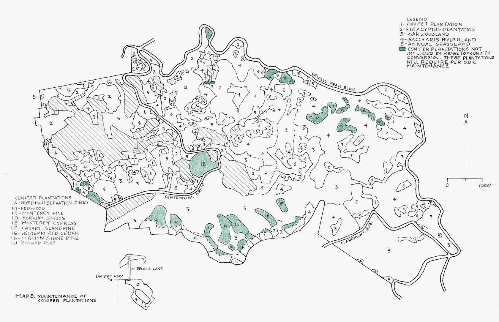
After the conversion of the conifer plantations occurring along the ridges in the study area there will be approximately 56 acres of remaining conifer plantations (see Map 8). The initial treatment of these plantations to eliminate fuel ladders, dead standing trees and accumulations of woody fuel on the ground is estimated to cost to $3,000 per acre for a total of $168,000 (Table 4). Periodic maintenance (every 5 years) of these conifer plantations is anticipated to cost $500 per acre for a total $5,600 every 5 years.
6. Establishment of ridgetop fuelbreaks
A fuelbreak along the ridgetop between Strawberry and Claremont canyons should be established to reduce the production of firebrands during a fire and to provide space for firefighters to suppress fire (Green, 1977). The fuelbreak should be 300 feet wide, going down slope 150 feet on each side of the ridge. Where non-University property occurs on one side of the ridgeline the fuelbreak should extend downslope 300 feet on University property. Twelve acres of baccharis brushland occurs within the proposed ridgetop fuelbreak (Map 9). This area of baccharis brushland must be converted to annual grassland and maintained as annual grassland. Approximately 12 acres of the baccharis brushland is within the area to be designated as an Alameda whipsnake preserve (see below). Removing 12 acres from the proposed 169-acre preserve will result in 157 acres for a preserve, an area slightly smaller than the 167 acres required by the U.S. Fish and Wildlife Service for a preserve. However, the Alameda whipsnake is known to use grassland areas adjacent to baccharis brushlands for both hunting and reproduction (EPA, 2010).

There are approximately 23.5 acres of conifer plantations within the proposed ridgetop fuelbreak. All of these will be converted to either grassland or oak woodland depending upon understory conditions during the conversion of conifer plantations on ridges (see 2 above). One- and one-half acres of annual grassland occur in the proposed ridgetop fuelbreak. No establishment technique is required for these acres. After the initial establishment of the ridgetop fuelbreak the grassland areas (existing prior to the establishment of the fuelbreak or established by removal of baccharis brushlands) are to be grazed by goats on an annual basis. Areas of oak woodland shaded fuelbreaks along the ridgetop are monitored and maintained every five years.
The overall cost for the establishment of the ridgetop fuelbreak, excluding costs associated with the conversion of eucalyptus and conifer plantations within the 300-foot-wide proposed ridgetop fuelbreak, is estimated to be $54,000 (Table 4). Annual maintenance cost for mowing grassland (both pre-existing and established) within the ridgetop fuelbreak will amount to $6,750 (Table 5). Monitoring and maintenance of the shaded fuelbreak within the ridgetop fuelbreak (exclusive of maintenance of shaded fuelbreaks established in the conversion of eucalyptus and conifer plantation will cost approximately $22,000 every five years (Table 5).
After the initial conversions, ongoing management should be provided by University staff, contractors, volunteers from local organizations, or by willing non-profit groups like the California Native Plant Society which handles the Skyline Garden Project for EBMUD.
7. Fuel maintenance along power lines
Power lines occur along the ridges and within Strawberry Canyon and along Grizzly Peak Boulevard, Fish Ranch Road, and along Claremont Avenue. Failure of power line equipment and contacts between power lines and tree branches have resulted in wildland fires. Pacific Gas and Electric Company (PG&E) recently revised its standards for the clearance of tree branches along power lines. The new, revised standards will require a clearance of 12 feet on each side of high voltage power lines (https://www.pge.com/en_US/safety/emergency-preparedness/natural-disaster/wildfires/vegetation-management.page) . Clearing vegetation along power lines is the responsibility of PG&E, who is also responsible for annual inspection of its power lines. The University of California and the Lawrence Berkeley National Laboratory should annually monitor electrical lines leading from the PG&E utility poles to structures and maintain clearance of tree branches around these lines.
Other fire management issues
Four additional fire management issues should be given consideration in Strawberry and Claremont canyons. These are (1) evacuation routes during a fire, (2) fire water supply, (3) purchase of fire trucks for wildland fire suppression and (4) improvements in fire detection. These issues are addressed in the following paragraphs.
1. Evacuation routes
Grizzly Peak Boulevard, Claremont Avenue and Centennial Drive will be used as evacuation routes in the event of a wildfire threatening the urban areas either north or south of Strawberry and Claremont canyons. The vegetation along these evacuation routes must be managed to minimize the possibility of trees and/or tree branches falling onto the road and blocking traffic. To minimize this potential any trees currently leaning over the roads should be removed. Any additional trees that lean toward the roads that are tall enough to fall onto the roads must also be removed. Periodic inspections (every 5 years) should be conducted to see if other trees within striking distance of the roads are exhibiting conditions (e.g., sudden oak death disease) that suggest they might likely fall onto the roads. Such trees should be removed. Tree removal must be augmented by the removal of all 1-hour and 10-hour fuels (terminology refers to the amount of time for a woody material to lose moisture based on size, usually under an inch in diameter for 10-hour fuels, (https://www.fws.gov/fire/downloads/monitor.pdf) resulting from the removal of individual trees.
The costs of establishing and maintaining roadside fuelbreaks along the evacuation routes is indicated above under “Establishment of roadside fuelbreaks.” An additional cost will be required for the removal of leaning trees that could fall onto the evacuation routes. There is no current estimate of the number of these trees along Grizzly Peak Boulevard, Claremont Avenue and Centennial Drive. Per tree cost of tree removal could range from $500 to $5,000.
2. Fire water supply
The water supply designated for firefighting should be increased in both Strawberry and Claremont canyons. Additional water tanks should be located along Grizzly Peak Boulevard to feed fireplugs along Grizzly Peak Boulevard, Claremont Avenue, and Centennial Drive. These storage tanks can also be used to fill tanker trucks engaged in fire suppression in the two canyons. Firefighting water storage facilities available to the Space Sciences Laboratory, Mathematical Sciences Research Institute, Lawrence Hall of Science, Botanical Garden, Landscape Maintenance Facility, Animal Behavior Research Center, Strawberry Canyon Recreation Area, and residence halls adjacent to wildland vegetation in Strawberry Canyon should be evaluated to see whether additional water storage for firefighting should be developed. Gravity feed systems need to be developed in view of PG&E’s plan to turn off electricity during periods of extreme fire weather (https://www.pge.com/en_US/safety/emergency-preparedness/natural-disaster/wildfires/public-safety-power-shutoff-faq.page).
3. Purchase of fire trucks for wildland firefighting
The University of California and the Lawrence Berkeley National Laboratory should purchase fire trucks designed for fighting wildland fires. It would be of particular value to have tanker trucks capable of delivering water for firefighting in the two canyons. One Type 3 fire truck should be purchased by each agency (University of California; Lawrence Berkeley National Laboratory). A Type 3 fire engine is typically a four-wheel drive apparatus designed for rapid deployment, pick up, and relocation during wildfires. Technically, a Type 3 fire engine includes a pump operating at 120 gallons per minute, a large 500-gallon tank, 1,000 feet of 1 ½ inch hose, and 800 feet of 1-inch fire hose. Type 3 fire engines can carry a minimum of four firefighters. Fire roads throughout both Strawberry and Claremont canyons should be modified, where necessary to accommodate the Type 3 fire engines purchased. Used fire engines are available and should be considered for purchase.
An alternative to the above would be for UC, LBL, EBRPD, and EBMUD to collaborate with the State to establish a Cal Fire unit station in the East Bay Hills, possibly with a temporary station at the service yard in Tilden Regional Park, and then by purchase of the abandoned property and structure on Fish Ranch Road near the Caldecott Tunnel and Highway 24 to construct a permanent Cal Fire unit station.
4. Improvements in fire detection
Early detection of wildland fires can be of great value in fire suppression. In the past fire lookout towers were used for surveillance of forest and wildland areas. A 40-foot-tall steel fire lookout tower was erected on Grizzly Peak in 1924 following the 1923 Berkeley Hills Fire. It was used for fire surveillance until 1960 when it was taken down. During the last 18 years of its operation 160 fires were spotted in the Berkeley Hills. More recent fire detection methods involve aerial patrols, ground observations from roads and fire trails and camera detection. PG&E has proposed the installation of several thousand cameras to detect and monitor the spread of wildfires in California (https://www.pge.com/pge_global/common/pdfs/safety/emergency-preparedness/natural-disaster/wildfires/Wildfire-Safety-Plan.pdf, p.91). The University, the LBNL, EBMUD, and EBRPD should make sites available for PG&E to install fire detection cameras on their property to monitor conditions in both Strawberry and Claremont canyons.
Impact of proposed fuel management on species of special interest and other species
The Alameda whipsnake (Masticophis lateralis ssp euryxanthus), a federally listed species, has been reported in Strawberry Canyon (U.S. Fish and Wildlife Service, 2002). It may also be present in Claremont Canyon. A second federally listed species, the pallid manzanita (Arctostaphylos pallida), has not been reported in either Claremont or Strawberry canyons but occurs nearby.
Although the Alameda whipsnake is associated with baccharis brushlands and coastal sage scrub, it moves into adjacent annual grasslands up to distances of 500 feet where it may stay for periods of a few hours to several weeks at a time (EPA, 2010). It utilizes grassland adjacent to brush dominated areas for mating, egg laying sites, and hunting for prey. It has also been reported in the margins of oak woodlands.
Many of the proposed fuel management techniques in this report could potentially negatively impact individual Alameda whipsnakes. In order to minimize that possibility the procedures outlined in the UC Berkeley 2020 Hill Area Fire Fuel Management Program (Morales, M. and Morales, T., 2003) for the protection of the Alameda Whipsnake will be followed. These measures include:
Installation of snake-proof drift fencing around the perimeter of all slash piles to be burned
All vegetation treatment activity except hand clearing of brush will be limited to fall and winter months, when snakes are expected to be underground and less susceptible to harm
A series of training sessions for contractors will be conducted to train personnel and develop an informational brochure to train personnel on identifying the Alameda whipsnake and methods to avoid disturbing it
Stationary equipment will be checked for the presence of Alameda whipsnakes prior to being moved
Potential Alameda whipsnake retreat habitats, (e.g., rock outcroppings) will be avoided by fuel management crews and vehicles
Potential Alameda whipsnake retreat habitats will be protected from fire by construction of perimeter control lines
Injured snakes will be captured and treated for injuries by the nearest cooperating wildlife rehabilitation center.

The U.S. Fish and Wildlife Service has required an area of 167 acres to be designated as a preserve for the Alameda Whipsnake. This area is to be maintained as baccharis brushland by the removal of tree species that emerge through the baccharis canopy. A contiguous area of 144 acres of Baccharis brushland occurs on the upper south facing slopes of Strawberry Canyon with 25 acres of non-contiguous baccharis brushland nearby (Map 10). This area should be set aside as the Alameda Whipsnake preserve and maintained as a baccharis brushland with the exception of those areas subject to ridgetop, roadside, and powerline fuelbreak establishment and maintenance. The area should be maintained as Baccharis brushland by the initial removal of trees that have emerged from the baccharis canopy and areas of broom (Genista monspessulana). It is estimated that the initial removal of trees and broom will cost $100,000. Periodic maintenance to control the establishment of trees and broom within the preserve are estimated to cost $16,900 (every 10 years).
Several species of ground, tree and shrub nesting birds occur in the study area. Fuel management activities should be restricted to the non-nesting season of these birds to minimize impacts to these species.
Prioritization and costs of fuel management activities
The fuel management activities identified above can be prioritized on the basis of their importance in addressing the fire hazard presented by the vegetation in Strawberry and Claremont canyons. It is important from the standpoint of fire safety to initially address the most hazardous fuels before initiating fuel mitigation problems in less hazardous vegetation types. With that approach in mind the following priority of fuel management activities is proposed:
Conversion of eucalyptus plantations
Conversion of conifer plantations on ridges
Establishment of roadside fuelbreaks
Establishment of ridgetop fuelbreaks
Establishment of shaded fuelbreaks
Maintenance of conifer plantations
The initial cost for implementing this fuel management proposal is estimated to be $3,431,750. Periodic maintenance costs will amount to $71,460/year. These costs are shown in tables 4 and 5.
Literature Cited:
Agee, James K., Bahro, Finney, et al. “The use of shaded fuelbreaks in landscape fire management.” Forest ecology and management 127.1-3 (2000): 55-66
Agee, J., Wakimoto, Darley, Bidwell. “Eucalyptus fuel dynamics, and fire hazard in the Oakland Hills.” California Agriculture 27.9 (1973): 13-15.
Boyd, David. 2019. “Eucalyptus globulus.” IPCW Plant Report. Berkeley, CA. California Invasive Plant Council (https://www.cal-ipc.org/resources/library/publications/ipcw/report48/).
Brown, Arthur Allen. 1973. Forest Fire: Control and Use. NY: McGraw-Hill.
Burcham, Lee T. 1957. California rangeland: an historico-ecological study of the range resource of California. Sacramento: California Department of Natural Resources, Division of Forestry; 261 pp.
California Department of Forestry and Fire Protection, Resource Management. “California Forest Practice Rules 2019.” Edited by Wade Porter and Thom Porter, California Forest Practice Rules 2019.
California Department of Forestry and Fire Protection, Office of State Fire Marshal. “Fire Hazard Severity Zones Maps.” 2019 (https://osfm.fire.ca.gov/divisions/wildfire-prevention-planning-engineering/wildland-hazards-building-codes/fire-hazard-severity-zones-maps/).
Cheney, N. P. (1981). Fire behaviour. In: A. Gill, R. Groves and I. Noble, ed., Fire and the Australian Biota. Canberra: Australian Academy of Science, pp.151-175.
Cheney, N. P. and G. A. Bary. 1969. Paper A-6, “The Propagation of Mass Conflagrations in a Standing Eucalyptus Forest by the Spotting Process.” Proceedings, 1969 Mass Fire Symposium. Canberra, Australia. Defense Standards Laboratory. Maribyrnong, Victoria, Australia.
Cheney, N. P., et al. “Predicting fire behaviour in dry eucalypt forest in southern Australia.” Forest Ecology and Management 280 (2012): 120-131.
Dahl, K., R. Licker, J. Y. Abatzoglou, and J. Declet-Barreto. 2019. Increased frequency of and population exposure to extreme heat index days in the United States during the 21st century. Environmental Research Communications 1(7):1-13.
Dennis, F. (2019). Fuelbreak guidelines for forested subdivisions & communities (https://mountainscholar.org/bitstream/handle/10217/45082/Fuelbreak_Guidelines_for_Forested_Subdivisions_Communities.pdf?sequence=1&isAllowed=y).
EBRPD East Bay Regional Park District. “Wildfire Hazard Reduction and Resource Plan,” 2010, (https://www.ebparks.org/about/stewardship/fuelsplan/plan.htm).
EPA, United States Environmental Protection Agency. Alameda Whipsnake: Endangered Species Facts, US EPA Office of Pesticide Programs, Endangered Species Protection Program (ESPP). February 2010 (https://www.epa.gov/sites/production/files/2013-08/documents/alameda-whipsnake.pdf)
Gould, J.S., W.L. McCaw, N.P. Cheney, P.F. Ellis, I.K. Knight, and A.L. Sullivan. 2007. Project Vesta—fire in dry eucalyptus forest: fuel structure, fuel dynamics, and fire behavior. Ensis-CSIRO, Canberra, Australian Capital Territory.
Green, Lisle. “Fuelbreaks and other fuel modification for wildland fire control.” Agricultural Handbook No. 499. 79 p (1977). Washington, DC: US Department of Agriculture, Forest Service.
Hamilton, D., J. McBride, and J. Laacke. East Bay Regional Park District (1974). The vegetative management plan for the eucalyptus freeze affected areas in the Berkeley-Oakland Hills. Oakland, CA: East Bay Regional Park District.
Hodgson, A. 1967. Fire management in eucalyptus. Proceedings of the 6th Tall Timber Fire Ecology Conference. Pp. 97-111 (http://talltimbers.org/wp-content/uploads/2014/03/Hodgson1967_op.pdf).
Husari, S, et al. “Fire and Fuel Management.” Fire in California Ecosystems, edited by H T Nichols, University of California Press, 2006, pp. 444–465.
Keeley, Jon E. “Fire history of the San Francisco East Bay region and implications for landscape patterns.” International Journal of Wildland Fire 14.3 (2005): 285-296.
Manzello, Samuel L., et al. Urban-wildland fires: On the ignition of surfaces by embers. US Department of Commerce. Technology Administration. National Institute of Standards and Technology. Building and Fire Research Laboratory, 2006 (https://tsapps.nist.gov/publication/get_pdf.cfm?pub_id=100838).
Morales, M., and T. Morales. UC Berkeley 2020 Hill Area Fire Fuel Management Program. Safe Solutions Group, El Sobrante, CA, 2003.
O’Brien, Bill. “Ubiquitous Eucalyptus.” Bay Nature. Bay Nature Institute, 1 July 2006 (https://baynature.org/article/ubiquitous-eucalyptus/).
Russell, R. J. “Climates of California.” University of California Publications in Geography, Vol. 2, No. 4. October 1926.
Russell, William H., and Joe R. McBride. “Landscape scale vegetation-type conversion and fire hazard in the San Francisco Bay Area open spaces.” Landscape and urban planning 64.4 (2003): 201-208.
Satomi, R. P. Mechanized forest fuel treatments: analyzing machine efficiency within variable landscapes. Diss. University of California, Berkeley, 2016.
SJSU Fire Weather Research Laboratory. “Diablo Winds.” San José State University, San José, CA, 2019 (https://www.fireweather.org/diablo-winds/).
US Fish and Wildlife Service. “Draft Recovery Plan for Chaparral and Scrub Community Species East of San Francisco Bay.” California. November (2002).Agee, James K., Bahro, Finney, et al. “The use of shaded fuelbreaks in landscape fire management.” Forest ecology and management 127.1-3 (2000): 55-66.